Sea level rise is accelerating. At some point, our barrier islands will cross a disintegration threshold and begin to disappear. Because every mile of every beach is created differently, we will see some beaches begin to suffer sooner than others.
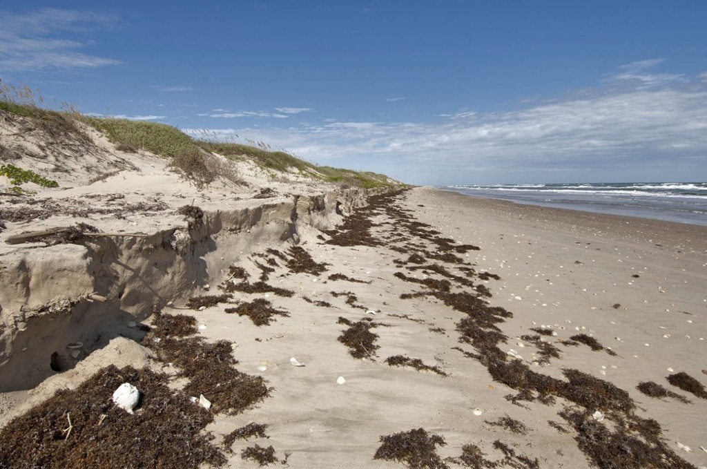
October 19, 2013, Padre Island National Seashore, low tide, Mile Marker 55 (50 miles beyond the four-wheel drive only sign). The seaweed drift marks the highest extent of the most recent high tide. The beach is basically impassible during high tide. This was the greatest erosion observed on the National Seashore this day. Photos (c) Bruce Melton / The Rag Blog.
PADRE ISLAND — For over 30 years I have been visiting Padre Island National Seashore, mostly as an official beach bum. My favorite thing to do on this narrow barrier island that protects the lower third of Texas’ coast is drive the four-wheel drive only beach. This place truly is a wilderness, or at least as close to one as we can get in Texas.
By about 2003 it became painfully obvious that sea level rise was causing the beach to shrink; this wasn’t just another natural cycle. In 2007 I began film work for my first sea level rise documentary that included Greenland, and Matagorda and Padre Islands (Matagorda Island is on the Middle Texas Coast and it too is a barrier island). The film is called The Ice and the Sea and can be seen here.
The film is about “The Big Melt” that began in Greenland and, beginning about 2003, what appeared to be a corresponding jump in sea level on Padre Island. Back in the 80s and 90s, the beach was literally hundreds of feet wide. Since the turn of the century though, the beach width has been dwindling.
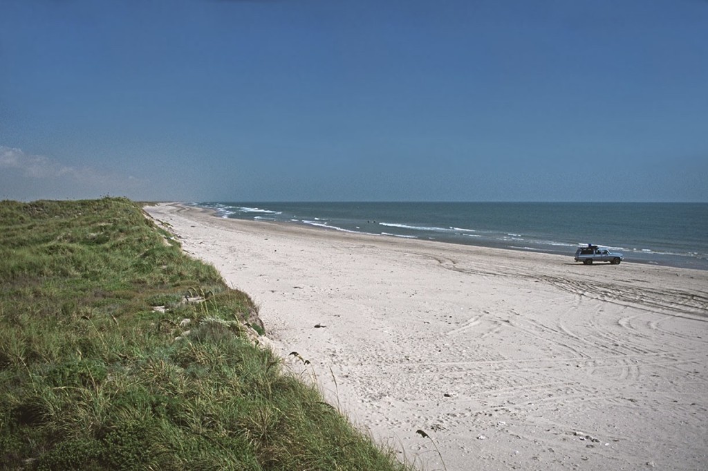
Padre Island National Seashore, 30 miles beyond the four-wheel drive only sign. As recently as 2003 the beach at Padre Island was hundreds of feet wide.
Last October, my annual fall trip to Padre left me dumbfounded with what I found. Way down the four-wheel drive beach in several places, the beach was simply gone. Beginning at about mile marker 55 and extending on down to about marker 58, the beach was impassible at high tide in three short places and at the foot of the dunes there was a vertical four-foot tall erosion cut.
This erosion was happening in the area of sand starvation just north of the Mansfield Pass jetties, 60 miles south beyond the end of the pavement on the National Seashore. Sand starvation in this area occurs because the currents on the Texas coast flow along the beaches depending on prevailing winds.
At Mansfield Pass, more southerly winds prevail and more sand drifts north in the surf. This northward drift is captured on the south side of the Mansfield Pass jetties and creates the sand starvation on the north side for several miles, which results in a smaller beach in this area than elsewhere.
The jetties have been there for almost 60 years, so this is nothing new. The beach has always been small for several miles north of the jetties, but only after storms is the beach impassable. No storms had come anywhere close to Padre last hurricane season.
What is new is that sea level rise has increased substantially since the end of the 1990s.
What is new is that sea level rise has increased substantially since the end of the 1990s. Normally sea level rise on Padre, between 1908 and 1999, has been about 5.2 mm per year. (1) About 2 to 3 mm of this is subsidence, or sand starvation or geologic compaction. Normally the beach at Padre is a receding beach because of this, but the beach width is usually much wider.
At times, storms will radically alter the beach, but our last several storms have not had a direct hit and only served to temporarily increase the beach size as the front of the dunes have been dragged down into the water by the small surges that we have seen.
What is going on here is that since the turn of the century we have seen an even greater increase in sea level rise than in the 20th century. In Greenland, “The Big Melt,” as the ice scientists call it, started contributing more to sea level rise about this time and Antarctic melt has also been increasing and our oceans continue to warm even faster which increases their volume as the warmer water expands.
The important thing to understand about sea level rise is that a beach’s natural ability to regenerate itself begins to fail with about 7 mm of sea level rise per year. (2)
Some places normally see a little more erosion than others because of any number of reasons. These places will be the first to show signs of beach disintegration. The precursor — beach shrinkage — is found everywhere along Padre Island’s 90-mile length today.
To the beach, it doesn’t matter where the sea level rise comes from: subsidence from oil extraction or water pumping, geologic beach compaction, sand starvation from inland reservoirs blocking the transport of sediment down rivers, or jetties.
On average, Texas’ coasts are sinking faster than the rest of the world by about 20 percent.
On average, Texas’ coasts are sinking faster than the rest of the world by about 20 percent. South Padre Island is sinking about 20 percent faster than North Padre Island.
Barrier islands, regardless of where they are located, all begin to disintegrate at about 7 mm per year of “relative” sea level rise. Relative sea level rise is all inclusive. Just because the average sea level rise globally is 3.7 mm per year does not mean that some places are not close to or above the disintegration threshold. Parts of the Alaskan coast are rising at 10 mm per year because of rebound after ice sheet melt during the last ice age.
What we are seeing now in some places on Padre is that relative sea level rise is exceeding this threshold and it will not be long until the entire island’s sea level rise rate exceeds the threshold.
The first week of April I was able to run the four-wheel drive beach on South Padre Island all the way from Brownsville to Mansfield Pass and what I found there was even more concerning than the erosion on the National Seashore on North Padre from last October.
South Padre has s half dozen places where the beach is gone for a couple of hundred feet to about a half mile. No storms, just normal monthly high tides. One has to drive in the surf, past tall eroded sand dunes, to get back on the beach trail which runs along only a 50 foot wide beach in many places. Some of the eroded dune faces were 12 to 18 feet tall. Even at low tide the truck still got its feet wet.
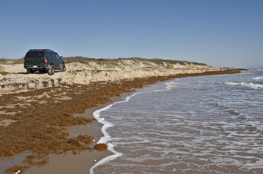
South Padre Island, April 7, 2014, about mile 17. The four-wheel drive trail still existed on a tiny beach just above this erosion cut.
To get through one has to time the waves, and then hurry or slow to a crawl depending on how high the water gets as the waves wash in beneath your truck. The gate keeper at Access Road 6 for the County Park — the last access road before pavement ends — said that in November the beach was closed 10 times because water had come all the way up to pavement on the inland side of the dunes. No storm, just the annual high tide.
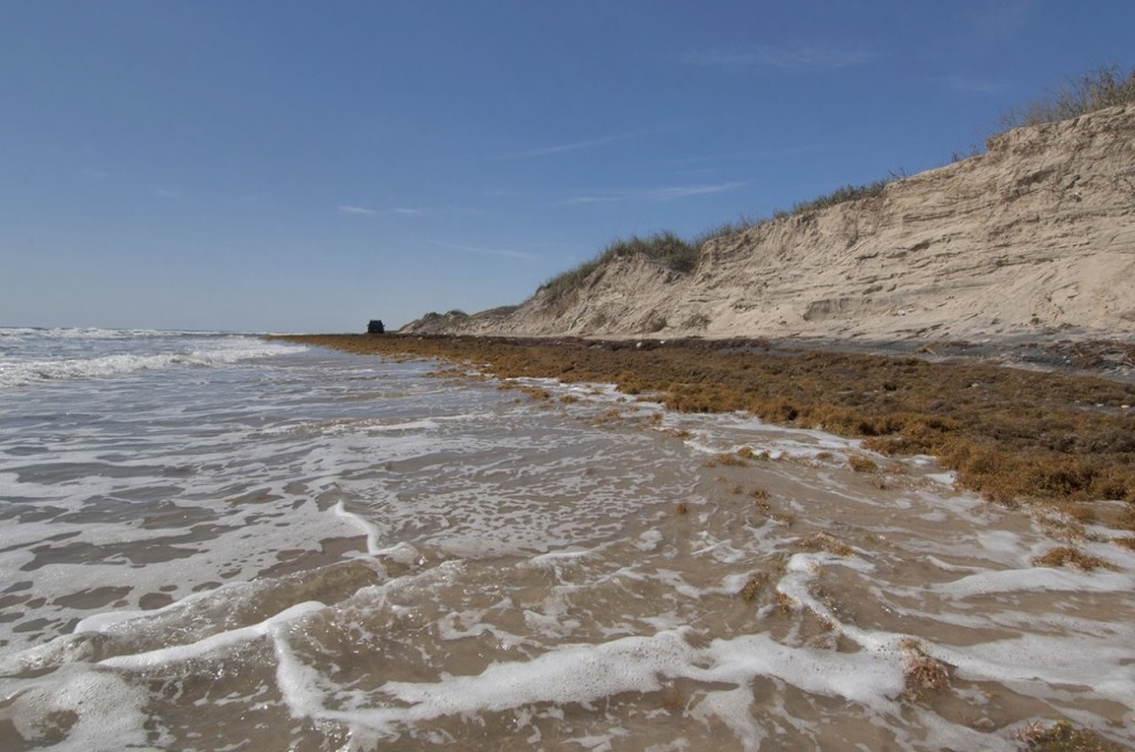
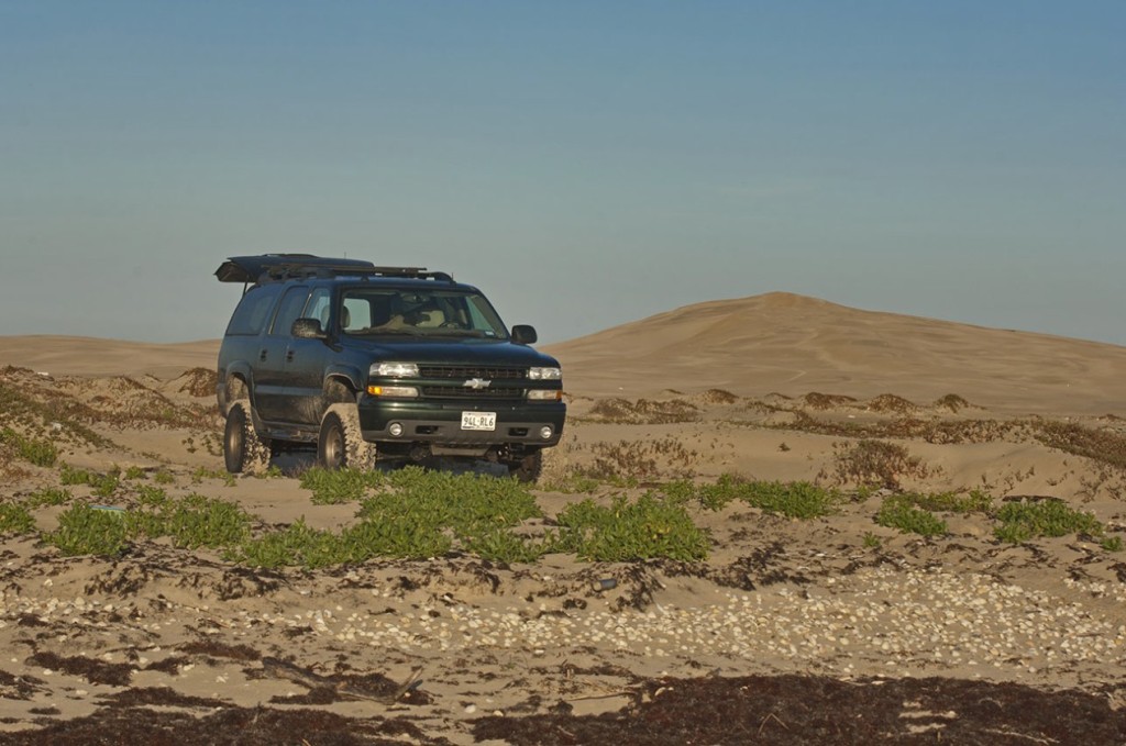
South Padre Island, mile 13.5, April 7, 2014. The eroded dunes tower over the little dark spot that is my Suburban.
Two local old timers I talked to said that in their 50 to 60 years of beaching on South Padre, they had never seen anything close to this except after a hurricane.
Part of what I do for climate science outreach is write songs about climate issues. You can see some video of this trip to South Padre set to one of my band’s songs here.
Padre Island National Seashore (North Padre) was a little bigger than last fall generally, but a big cold front had just blown in as I arrived on April 7. Nowhere was the beach wider than about 80 feet from the base of the dunes to the normal high tide mark. The cold front had blown the water out to create some really low tides. I had 18 miles of easy driving on hard packed sand, but this gave way farther down the beach to the usually grueling slog along a faint trail in very deep sand and a beach that was 40 to 60 feet wide or less.
The eroded areas from last October at mile 55 now have a 20- to 30-foot wide beach above the high tide mark.
The eroded areas from last October at mile 55 now have a 20- to 30-foot wide beach above the high tide mark where the trail runs, but there was new erosion from winter’s high tides on the dune side of the trail with one to three foot tall erosion faces at the foot of the dunes. These began at mile 42 and became continuous at mile 48 all the way to mile 60 at Mansfield Pass.
The flats on the back side of the island on the Laguna Madre are still covered up with water, maybe 20 percent less than last October in some places. I have never seen them covered up. They do get covered up after hurricanes when storm tides invade the Laguna Madre or when lots of rain falls inland. In other places though there was no sign of the flats, it was all water all the way across the Madre five miles to the mainland.
Padre is still a wild and beautiful place, maybe even more wild since the four-wheeling is so tough with the bad trails and the challenges of the water crossings. There were even fewer folks way down the beach than usual. The U.S. Fish and Wildlife Turtle Patrol was in force, looking for the nesting endangered Kemp’s Ridley sea turtles. The season had just started, no turtles yet, but Turtle Camp at mile 35 was full of young biologists on ATVs driving 10 hours and a hundred miles a day on that grueling beach trail.
There are still some really cool places and some really big beach on South Padre.
There are still some really cool places and some really big beach on South Padre as compared to North Padre where the entire beach is lined with big dunes and in the whole 60 miles rarely does the beach approach 100 feet in width. South Padre gets less rain, so the dune grass is not as vigorous and damage from hurricane washovers is slower to self-repair. It is at these washovers from Hurricane Brent in 1998 that there is still a wide and beautiful beach.
A washover area from hurricane Brent in 1998 at about mile 17 on South Padre Island. South Padre gets less rain than North Padre so dune grass growth and dune regeneration are slower here than on North Padre.
The Polar Vortex this winter (a climate change enhanced weather phenomenon) created cold that was unusual for the last 20 years that stunned lots of turtles. Seven hundred were rescued and about a hundred fatalities were reported. That’s a lot of turtle rescues! Thanks to USFW, the National Park Service, Texas State Parks, all the South Padre Island turtle people, and all the volunteers up and down the coast.
And don’t forget, the solutions to climate pollution will be no more costly than what we spend on advertising across the planet every year — at the worst. And we have choices. At the best an alternative energy infrastructure installation for something the size of New York State will cost $500 billion over 20 years and once completed will results in $114 billion a year in savings and profits above a fossil fuel energy infrastructure.
If we really get a move on, new air capture technologies, once fully industrialized, will allow us to capture 50 ppm of CO2 from the atmosphere for the cost of health care in the U.S. in 2005 — effectively ending the climate pollution crisis. (3)
Read more articles by Bruce Melton on The Rag Blog
[Bruce Melton, a regular contributor to The Rag Blog, is a professional engineer, environmental researcher, filmmaker, and author in Austin, Texas. Information on Melton’s new book, Climate Discovery Chronicles, as well as more climate change writing, climate science outreach, and critical environmental issue documentary films can be found on his website and at www.climatediscovery.com. Photography copyright Bruce Melton 2014.]
References:
(1) Average sea level rise of 5.2 mm per year, about 2 to 3 mm per year due in some form to subsidence, compaction and or sand starvation… The wording in this research that defines the long-term sea level rise rate for 1908 to 1999 on Padre Island is: “The actual water level record recorded by the Pier 21 tide gauge on the bay side of Galveston Island was modified to serve as input to the habitat transition model. This tide gauge has recorded a 96-year record of relative sea level change, and the mean sea level trend from 1908 to 1999 was a rise of 6.5 mm/yr (Zervas, 2001). The Rockport gauge is closer to the study area, but its record only goes back to 1948 and there is a gap from 1955 to 1963. The Rockport record is long and complete enough, however, to calculate a long-term sea-level rise rate of 5.2 mm/yr and the decadal scale variation in water level is similar to the Pier 21 record. The Pier 21 record, therefore, was adjusted to have a long-term linear trend equal to the Rockport location, and this time series was used as input to the model.”
Gibeaut, et al., Estaurine wetland habitat transition induced by relative sea level rise on Mustang and North Padre Islands, Coastal and Marine Geospatial Laboratory, Harte Research Institute, Texas A&M University – Corpus Christi, 2010, page 14, Relative Sea Level Change, paragraph 1.
http://www.glo.texas.gov/what-we-do/caring-for-the-coast/_documents/grant-project/08-021-final-rpt.pdf
(2) Sea level rise and the 7 mm per year barrier island disintegration threshold… Padres Island is a “wave-dominated barrier island” that behaves similarly to wave-dominated barrier islands on the Atlantic coast of the U.S. Paragraph 3, page 56 of this report states: “For Scenario 3, it is very likely that the potential for threshold behavior will increase along many of the mid-Atlantic barrier islands.” Scenario 3 as evaluated in this report is 7 mm of increasing sea level rise per year.
Coastal Sensitivity to Sea-Level Rise: A Focus on the Mid-Atlantic Region, U.S. Climate Change Science Program, U.S. Environmental Protection Agency (EPA), in collaboration with the U.S. Geological Survey (USGS) and the National Oceanic and Atmospheric Administration (NOAA), 2009, Chapter 3 Ocean Coasts, 3.7 Potential Changes to the Mid Atlantic Ocean Coast due to sea level rise, 3.7.3 Wave-Dominated Barrier Islands, pages 55 and 56.
http://tinyurl.com/l9wfs4l
(3) Melton, A Fossil Fuel-Free New York State by 2050, Truthout.org, May 26, 2013.
http://www.truth-out.org/news/item/16540-a-fossil-fuel-free-new-york-state-by-2050


This is just the kind of evidence that deniers dismiss, and believers get the jitters over. Fortunately, attitudes are changing fast. Let’s just hope fast enough.
14,650 years ago there was thought to have been a very rapid destructive sea level rise.
In the last 112 years the sea has risen 7 inches. .0625 inches a year. Man pales in comparison to what nature does on her own. As of now the Arctic is melting at a fast rate but there are record rates of ice gains in the Antarctic. We are currently much better off than we were in 2012.