
East Coast Filming 2024
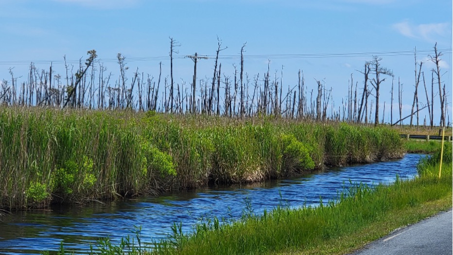
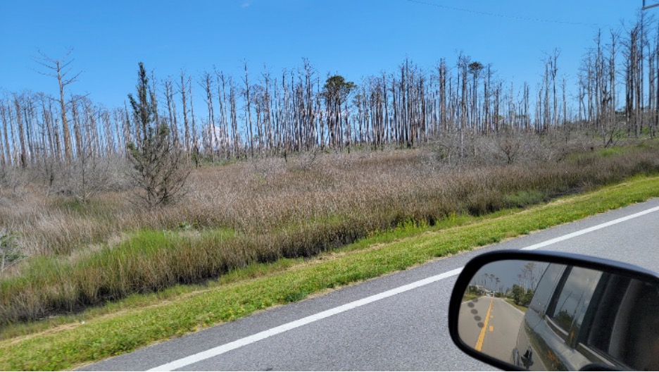
Forest kill from salt water intrusion, Alligator River National Wildlife Refuge, North Carolina.
By Bruce Melton | The Rag Blog | July 26, 2024
[Listen to Bruce Melton discuss the issues raised in this article on Rag Radio with Thorne Dreyer, Friday, July 26, 2-3 p.m. or stream at KOOP.org. After broadcast, the show will be posted at the Internet Archive. Listen to all Rag Radio shows featuring Bruce Melton here.]
We are just back from East Coast filming work. It was a bit of a surprise that the King Tide was not prominent, but there were a couple of other surprises that were not expected. Forest impacts along the coast from sea level rise salt water intrusion was much worse than anything I have seen in the popular media or in academic literature, and it approached the extreme of beetle kill in western North America. General forest mortality inland, from East Texas, Arkansas, Kentucky, Tennessee, North Carolina, Maryland and Virginia, was also much greater than anticipated
King Tide… Initially, this trip was a King Tide observation. But there was very little to see in the way of big tides and a few things that are different from Texas can explain the difference in what we anticipated and what we observed. The east coast King Tide charts appear to show a smaller series of tides in the spring than in the fall, relative to Texas where the two periods are similar in magnitude. I haven’t realized this before because this is our first trip east. All our King Tide work has been on Padre Island in the western Gulf of Mexico. It is still not apparent to me exactly why there is this difference between the East Coast and the Gulf Coast, but probably it is geographic reasons, or maybe predominant winds or possibly the influence of the Gulf Stream along the Outer Banks where we observed. The other thing is that the East Coast beaches are different than Texas’.
The sand is much deeper and softer on the East Coast, at least from the Delmarva Peninsula south to Cedar Island at the Banks. It either has a different grain size distribution or maybe the grains themselves are rounder or more polished by higher wave energy. If there are many different grain sizes, the sand (or soil) will pack well, where if there are few different grain sizes, the sand behaves like a box full of BBs when you try and walk or drive across it you sink.
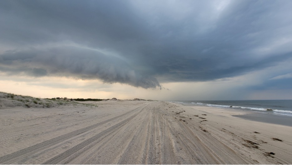
Assateague Island beach and storm cloud panorama.
What this grain size difference means, besides making normal beach driving almost impossible, is allows a taller surf ramp or foreshore to form that is five to seven feet high. This is the area where waves wash ashore or “swash” back and forth up the beach. The Texas foreshore is not as tall (a few feet), and it is much wider than the East Coast. The smaller spring season King Tides then, do not make much of an impression on the beach. We saw wave runup debris from King Tides at the maximum high tide mark above the foreshore, but not into the dunes.
The coastal observations this trip were Fenwick and Assateague Islands, and the Outer Banks: Carova and Corolla beaches to the north and Brodie, Pea, Hatteras and Ocracoke Islands along the Banks proper south of Kitty Hawk, Kill Devil Hills and Nags Head. Our path covered about 275 miles of coast in Delaware, Maryland, Virginia and North Carolina, but we were only able to drive about 50 miles of beach, which is most of the drivable beach here where tourist and beach owners lay claim to beach and law does not demand the beach be open to the public like in Texas.
The beach was in tolerable shape with some very narrow sections where the foreshore abutted the dunes, but few of these. It is difficult to say how much of the former beach has been eroded as we have no long-term anecdotal observations here like we do in Texas where the beach is a shadow of its former self (except in high tourism value nourished areas). Most of the beaches we visited were nourished with sand dredged from offshore, often multiple times over the years.
The first surprise of the trip was the extent of salt water intrusion forest mortality on the Banks Islands themselves, as well as along the sounds inland, was far greater than reported in the literature and popular press. The likely reason is that science is slow and the popular press mostly queues off of publishing of scientific literature and associated press releases.
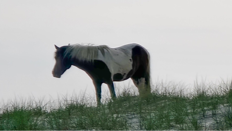
Assateague Island Ponies.
The science is slow because first, a phenomenon must be identified, then natural systems data collection takes time. Then, data must be interpreted and a significant challenge arises here. A changing trend (rapidly increasing degradation) is difficult to “see” with statistics. Averaging a rapidly increasing number of tree mortalities with a longer record of far fewer tree mortalities biases the current rapid trend low, or understates its true impact. And, the publishing process can easily take another year. This entire process can easily total a decade. When natural system impacts are progressing year to year, the actual fate of the ecologies can be far advanced from the published findings and associated popular press.
All along the 275-mile coastal stretch we observed, we saw substantial area of ghost forests (forest mortality) from salt water intrusion due to sea level rise with 30 percent to 100 percent mortality. Everywhere was mortality, though to the casual observer, 30 percent kill blends in with the remaining forest to give an impression of health.
Sea level rise along the Banks since 1977 has been a foot or a little more (see NOAA’s sea level rise tracker here). This is significantly greater than the global average because of regional subsidence since the last ice age (a small amount) and because of a slowing of the Gulf Stream. There is a large pool of cool, less salty water off Newfoundland, that has accumulated there from melt in Greenland and from freshwater exiting the Arctic because of loss of sea ice. (When salt water freezes, it expels the brine, that sinks in concentrated form into the depths.) When sea ice melts then, the less salty water pools near the surface and natural currents move the surface waters out of the Arctic where it joins with Greenland melt off Newfoundland
This less salty water floats on top of the rest of the ocean because it is lighter than the saltier water. This creates a dam in the North Atlantic, the slows the northward flow of the Gulf Stream. This damming causes the upstream water in the Stream to the south, to increase in elevation, and this the reason why the East Coast of the U.S. is seeing some of the highest sea level rise rates in the world.
At the Cape Hatteras National Seashore, Bodie Island Lighthouse Road had some forest salt water mortality, but not a lot of forested area in total. The worst area on the islands we saw was on the northern part of Ocracoke island just south of the northern ferry landing where junipers were failing. On the Ocracoke to Cedar Island Ferry we saw a lot of juniper mortality on the sound side of the southern end of Ocracoke Island and much of Portsmouth Island.
We did an intensive study of about 80 miles of mainland shore inland of the sounds behind the Banks (Pamlico Sound mostly) from Nags Head to Cedar Island in the Alligator River and Cedar Islands National Wildlife refuges. The mortality was not as widespread on the Islands of the Outer Banks, though the ecologies were grassy shrub marshes and sandy barrier island woodlands instead of mucky wetland pocosin. On Assateague Island, we found horses and some pretty significant tree mortality right around the ranger station.
Alligator River National Wildlife Refuge… Salt water intrusion from sea level rise has resulted in significant forest mortality in much of these refuges. Alligator River refuge is located just across the causeway from Nags Head at the Outer Banks. The refuge was created to preserve the pocosin wetland here, that once lined the East Coast from Virginia to Florida. Here, the pocosin is a forested wetland with deep sandy peaty mucky soils and a shallow freshwater aquifer sitting atop a saltwater aquifer from the Sound. The forest mortality from saltwater intrusion occurs two ways here.
Forest kill from salt water intrusion, Alligator River National Wildlife Refuge, North Carolina.
The first surprise of the trip was the extent of salt water intrusion forest mortality on the Banks Islands themselves, as well as along the sounds inland. It was far greater than reported in the literature and popular press. The likely reason is that science is slow and the popular press mostly queues off of publishing of scientific literature and associated press releases.
The science is slow because first, a phenomenon must be identified, then natural systems data collection takes time. Then, data must be interpreted and a significant challenge arises here. A changing trend (rapidly increasing degradation) is difficult to “see” with statistics. Averaging a rapidly increasing number of tree mortalities with a longer record of far fewer tree mortalities biases the current rapid trend low, or understates its true impact. And, the publishing process can easily take another year. This entire process can easily total a decade. When natural system impacts are progressing year to year, the actual fate of the ecologies can be far advanced from the published findings and associated popular press.
All along the 275-mile coastal stretch we observed, we saw substantial area of ghost forests (forest mortality) from salt water intrusion due to sea level rise with 30 percent to 100 percent mortality. Everywhere was mortality, though to the casual observer, 30 percent kill blends in with the remaining forest to give an impression of health.
Sea level rise along the Banks since 1977 has been a foot or a little more (see NOAA’s sea level rise tracker here). This is significantly greater than the global average because of regional subsidence since the last ice age (a small amount) and because of a slowing of the Gulf Stream. There is a large pool of cool, less salty water off Newfoundland, that has accumulated there from melt in Greenland and from freshwater exiting the Arctic because of loss of sea ice. (When salt water freezes, it expels the brine, that sinks in concentrated form into the depths.) When sea ice melts then, the less salty water pools near the surface and natural currents move the surface waters out of the Arctic where it joins with Greenland melt off Newfoundland
This less salty water floats on top of the rest of the ocean because it is lighter than the saltier water. This creates a dam in the North Atlantic, the slows the northward flow of the Gulf Stream. This damming causes the upstream water in the Stream to the south, to increase in elevation, and this the reason why the East Coast of the U.S. is seeing some of the highest sea level rise rates in the world.
At the Cape Hatteras National Seashore, Bodie Island Lighthouse Road had some forest salt water mortality, but not a lot of forested area in total. The worst area on the islands we saw was on the northern part of Ocracoke island just south of the northern ferry landing where junipers were failing. On the Ocracoke to Cedar Island Ferry we saw a lot of juniper mortality on the sound side of the southern end of Ocracoke Island and much of Portsmouth Island.
We did an intensive study of about 80 miles of mainland shore inland of the sounds behind the Banks (Pamlico Sound mostly) from Nags Head to Cedar Island in the Alligator River and Cedar Islands National Wildlife refuges. The mortality was not as widespread on the Islands of the Outer Banks, though the ecologies were grassy shrub marshes and sandy barrier island woodlands instead of mucky wetland pocosin. On Assateague Island, we found horses and a some pretty significant tree mortality right around the ranger station.
Alligator River National Wildlife Refuge… Salt water intrusion from sea level rise has resulted in significant forest mortality in much of these refuges. Alligator River refuge is located just across the causeway from Nags Head at the Outer Banks. The refuge was created to preserve the pocosin wetland here, that once lined the east coast from Virginia to Florida. Here, the pocosin is a forested wetland with deep sandy peaty mucky soils and a shallow freshwater aquifer sitting atop a saltwater aquifer from the Sound. The forest mortality from saltwater intrusion occurs two ways here.
The rising sea level pushes the salt water aquifer up into the root fields of established forests and poisons them, as most of the species here only grow in freshwater wetlands. The other mortality agent is the network of ditches and canals built in the area before refuge acquisition in 1984, that were meant to drain the swamp and allow agriculture and forestry activities, and that are mostly still required to service private land around the refuge and the Navy bombing facility within the refuge. Higher sea level today allows salt water to penetrate the freshwater wetlands via these drainage ditches and canals and tide after tide, the salt water slowly poisons the plant species that are intolerant of salt water.
Dieback is enhanced by previous forestry and agriculture, where both logging and clearing for planting, have degraded the soils of the pocosin wetland, creating an unhealthy ecology before sea level rise introduced more salt water into the area. Some forested areas never cleared are tall and lush, while others lacking salt water mortality or stunted and sickly.
We traversed the refuge via US 264 that mostly parallels Pamlico Sound about a mile or three inland, with various oyster shell side roads penetrating the refuge deeply. Some areas of the refuge were unaffected, but large areas were badly degraded with mortality of pines and broad leaves at 100 percent. Mortality was widespread in the refuge for 35 miles along US 64.
Two other interesting things occur here relative to salt water mortality: The shrubby species do well, either because they are salt water tolerant, or because their root systems do not penetrate all the way to the rising salt water aquifer. The other is that when old forest succumbs, new vigorous forest species regenerate, but only up to a point. In some areas the 10 to 15-foot tall regrowth of pines for example, are now significantly degraded and quite sickly, because their roots have now reached the salt water aquifer and are suffering the same fate as their mature predecessors.
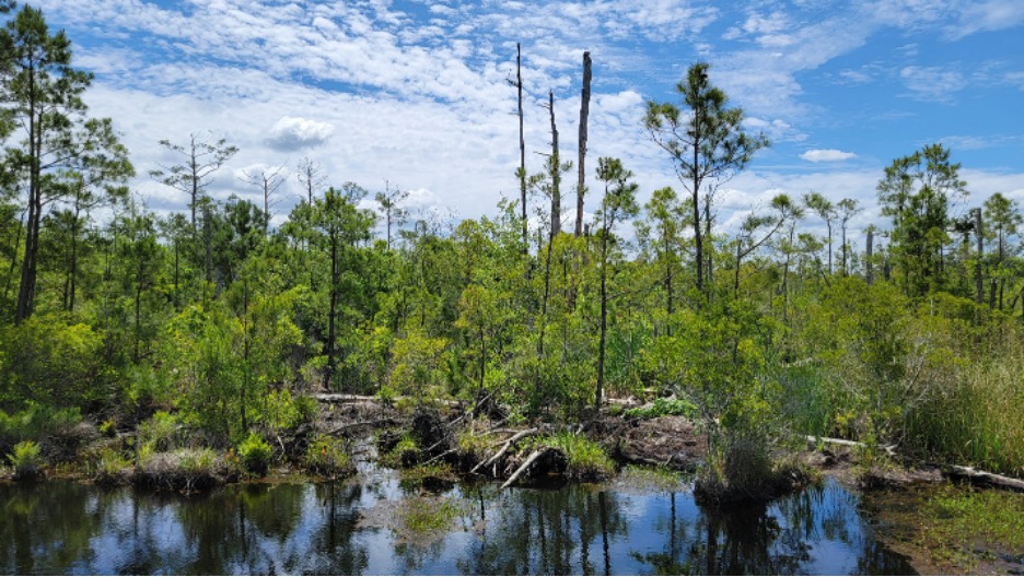
The same story was told at Cedar Island National Wildlife Refuges at the ferry landing from Ocracoke Island. In many areas, for miles sometimes, mortality was 100 percent or very near there.
Forest kill from salt water Intrusion, Cedar Island National Wildlife refuge, North Carolina.
The second surprise of the trip, besides all the fabulous birds nesting and singing their hearts out, was significant inland forest degradation along almost every single mile of this 7,000 mile witnessing.
We studied Mammoth Cave National Park, Shenandoah National Park, Great Smoky Mountains National Parks, and parts of the Blue Ridge Parkway (which is operated by the National Park Service), and literally, thousands of miles of highway in between. Forest damage and mortality from borers, blights and beetles was always evident at the minimum doubling or tripling natural mortality. At higher elevations mortality was increased as stress from warming is more predominant at altitude, furthering the degradation caused by insects and disease.
Some of the mortality was upland damage from the imported emerald and native long-eared ash borers, or various blights and bark beetles. Two other non-native insects, both mealy bugs, are creating havoc in the east coast forests: the balsam woolly adelgid and the hemlock wooly adelgid. These are tiny pinhead-sized insects that can attack by the tens of thousands. They have in them a toxin that can kill trees if there is a large enough attack, or continuous years of sap sucking can so stress trees they succumb to other mortality agents. All of these insects’ attacks are enhanced by increased stresses from climate change.
The second surprise of the trip, besides for all the fabulous birds nesting and singing their hearts out, was significant inland forest degradation along almost every single mile of this 7,000 mile witnessing.
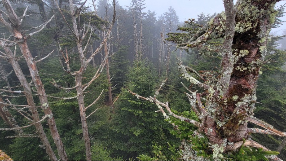
Balsam woolly adelgid mortality in Fraser fir at Klingman Dome, Great Smokey Mountain National Park.
We studied Mammoth Cave National Park, Shenandoah National Park, Great Smoky Mountains National Parks, and parts of the Blue Ridge Parkway (which is operated by the National Park Service), and literally, thousands of miles of highway in between. Forest damage and mortality from borers, blights and beetles was always evident at the minimum doubling or tripling natural mortality. At higher elevations mortality was increased as stress from warming is more predominant at altitude, furthering the degradation caused by insects and disease.
Some of the mortality was upland damage from the imported emerald and native long-eared ash borers, or various blights and bark beetles. Two other non-native insects, both mealy bugs, are creating havoc in the east coast forests: the balsam woolly adelgid and the hemlock wooly adelgid. These are tiny pinhead-sized insects that can attack by the tens of thousands. They have in them a toxin that can kill trees if there is a large enough attack, or continuous years of sap sucking can so stress trees they succumb to other mortality agents. All of these insects’ attacks are enhanced by increased stresses from climate change.
Very few areas contained no kill, but most areas the kill was muted as the bones of deceased trees rapidly are covered up by their neighbors’ enhanced growth from greater availability of water, light and nutrients with fewer trees. All the way from North Carolina back to the forests of northeast Texas the story was the same with persistent and moderate mortality certainly greater than a doubling or tripling of natural mortality.
This mortality is generally not visible to the average Karen and Joe Sixpack that do not pay attention to forest dynamics. Normal mortality in a forest is something like 1 in 100, 1 in 200, or 1 in 400 every year, depending on the forest species, longevity, moisture availability, and fire return period. Seeing a doubling of mortality then takes a sharp eye, with a concerted effort.
We picked up one additional forest mortality area I didn’t know about. This was recent drought or juniper bark beetle kill in Texas between Palestine and Bryan. This is new in the last year or two as the junipers are still retaining their brown needles.
Surprises of the trip:
The extent of minor to modest mortality across the entire Eastern U.S. (along our route) was not anticipated. This increased forest mortality supports work that shows across the world our forests have seen on average a doubling or more of mortality, flipping them (on average) from sequestration to emissions. This is counterintuitive because of the large amount of sequestration done by healthy forests. Per unit area, sequestration for trees is quite small, it is the vast area of global forests that create significant carbon absorption. It is logical then that academic work showing a simple doubling of forest mortality creates emissions instead of sequestration as when mortality doubles, generally and on average, forest age and carbon storage are halved.
We have seen the trunks and branches of deceased trees fade back into the forest all across the West, so this observation of widespread minor to moderate degradation in the East was not really that unanticipated. We have also seen young vigorous forests in the West appear to regenerate after beetle attack and fire, but this regeneration is likely fleeting as 30 percent of burned forests are not regenerating at all (where beetle kill and burn are likely behaving similarly), and half of the remaining are doing so at only half of the 20th century rate. This is a function of drought stress and continued insect and disease. In the east, very few fires and massive beetle attacks exist, but general mortality from insects is ever-present, and the huge mortality from salt water intrusion paints a different regeneration story
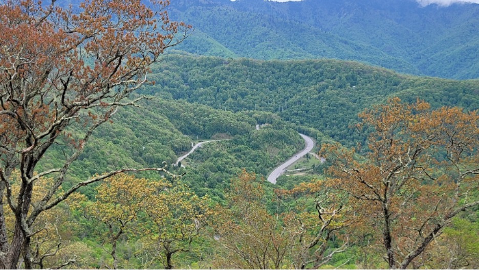
Far View in Great Smokey Mountain National Park, May 17, 2024. The golden trees are spring at the highest elevations in the park.
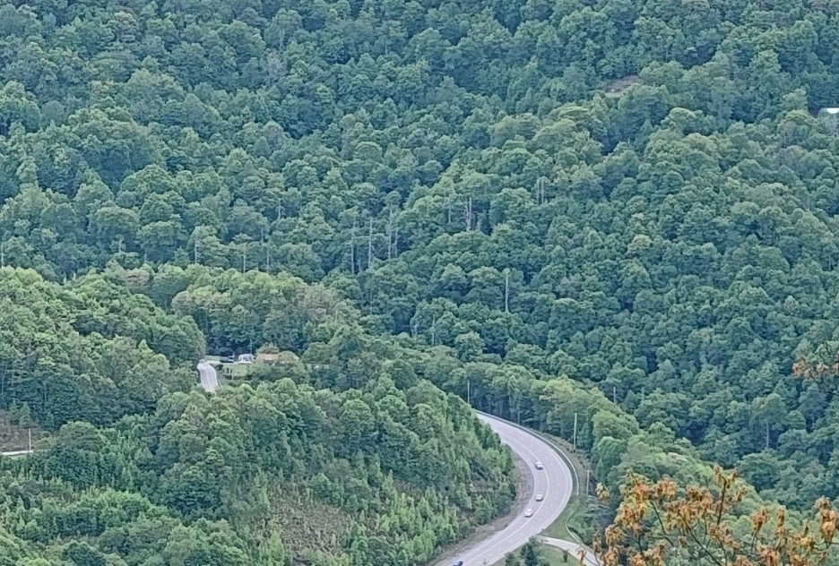
Crop of the above Far View Great in Smokey Mountain National Park. Looking closely, a lot of dead tree bones ar.e sticking up in this area, far more than a tree or two per couple of hundred that represent normal forest mortality. This view too, reveals nowhere near the actual number of ghost trees that one can observe up close from within the forest
[Bruce Melton is a professional engineer, environmental researcher, filmmaker, climate science education specialist, author, and director of the Climate Change Now Initiative founded in 2005. He has written over 500 reviews of academic climate science, lectures regularly, and has recently been involved in groundbreaking climate policy development where he was awarded a special achievement award by the Sierra Club for helping in the establishment of new climate policy and a safer limit to warming of “less than 1.0 degrees C above normal,” that reverses already initiated ecological collapse and climate tipping and restores extreme weather mayhem back to its former rare levels. You can see his climate science reviews and films at ClimateDiscovery.org, and his counterintuitively beautiful climate change photography at ClimateChangePhoto.org.]